- Overview
- Trip Outline
- Trip Includes
- Trip Excludes
- Gallery
- Booking
- FAQ
Name of Trek:Pin Bhaba Pass Trek
Duration: 07 nights/08 days
Grade: Moderate to Difficult
Maximum Alltitude: 4900 mtr/16,100 ft
Pickup and Drop Point: Shimla
Region: Himachal Pradesh
Pin Bhaba Pass Trek Highlights: Green Jungle to Desert Magic
Picture hiking from Bhaba Valley's thick green forests straight into Pin Valley's bare desert vibes—like flipping between two worlds on one trip through Himachal Pradesh.
Quick Facts
-
Total distance: 28-32 km over 7 days
-
High point: Pin Bhaba Pass at 16,100 ft (4,915m)
-
Starts in Kafnu (apple orchards), ends in Mudh (Spiti)
-
Best time: July-Sept for monsoon flowers, fewer crowds
-
Difficulty: Moderate-hard with steep pass day
Top Sights & Feels
-
Early days: Lush woods, wildflower fields, and riverside camps that look like postcards.
-
Pass summit: Killer 360° views over both valleys—worth every sweaty step.
-
Pin Valley shift: Mountains glow pink, purple, brown—like a painted dream.
-
Village charm: Chat with locals in Kafnu's fruit groves or Mudh's high-desert homes.
Why It's Special
New scenery every hour—forests, meadows, deserts, rivers—photo heaven with changing light. Quiet trails show off rainy-season Himalayan glow.
Itineraries
Day 1
Shimla to Kafnu
Once you arrive at Shimla, get ready to start a long journey to Kafnu. The day will begin early and our representatives will pick you up from Old Shimla Bus Stand. Kafnu is a serene village, remotely situated, almost 200km away from Shimla in the southern parts of Himachal Pradesh. Although there isn’t anything else on our schedule today since it is a long drive to Kafnu, starting as early as possible is always better. The ride will be 7 hours long but the road comes with beauty and joyride of turns and twists. Kafnu is a known village of Kinnaur due to the Hydroelectric project. Kafnu is a year-round vacation spot near Shimla and as such, there is good connectivity through buses from Rampur.
On the way, you can sight India’s first underground Hydroelectric project. A stunning blue lake is formed near the dam. En route, you will catch scenic mountain views with colourful roofs appearing and disappearing, as you cross tiny mountain settlements. The Sutlej River runs in the rocky background of the mountains. The moment you get closer to the village you can find views of Bhabha valley. After you cross the Wangtoo Bridge, you can see the Kinnaur Ranges appearing in clear view. Once you reach Kafnu, you can see the slopes of the village covered in apple orchards and the beautiful Sutlej River circling in and out of the village. Kafnu is a great place to start your Pin Bhaba Pass Trek. At the end of the drive, a warm stay will be waiting for you. Rest in your hotel for the night, because a beautiful trek is awaiting you.
Day 2
Kafnu to Mulling
The first day of the trek begins from Kafnu. You can consider this day as a wholesome day with 8-9 hours of a hike up through the trail of ascension. It will get you all pumped up for the surprises following next. The trek will bring rarely-seen sights of dense Pine forests and gushing rivers. The challenge of today's trek is the length of the walk and also the gain in altitude. Within a span of 11 km, you will also gain an altitude of 850 m. This means it’s going to be a steady incline with some plain patches here and there.
Immediately, when you start at 200 meters you can see India’s first underground Hydel project dam. Although photography is not allowed, make sure you capture the sight in your mind. To start with the hike is a walk of almost two and a half kilometers on a service road. Enjoy the lively surroundings and be prepared for 2800 feet of height gain. Initially, you will walk on a motorable road in the vicinity of the Janglik Range with the Bhaba River flowing close by you. This motorable route will lead to a small path where the actual trekking path starts. Before this, you will cross a bridge on the Bhabha River. This bridge will take you to the left bank of the River.
You will be trudging slowly between silver birch, oak, and pine trees. It is a dense forest harboring birds that keep you enthusiastic with their chirpy sound. You will walk under this salient flora for 5.5 km. The tall alpine trees will make the hike soothing for the eyes and unique. You can see the valley gets narrow and you will be on the left bank of the Bhabha river. Some further walks will take you to a clearing, where the terrain is strewn with mud, small stones, and grass.
The next big spot that comes after 1.4 km is the alluring camp of Champoria. The campsite is wonderful with trees around it. Cross another bridge ahead of the campsite. After crossing the walk on the right bank of the Bhabha River. The ascending trail will then start. The trail is 2 km take your steps slowly until you reach Jhandi Top(10,640 feet). You can rest on the Jhandi Top while soaking in the beauty surrounding you. You can also see your destinations Mulling from here.
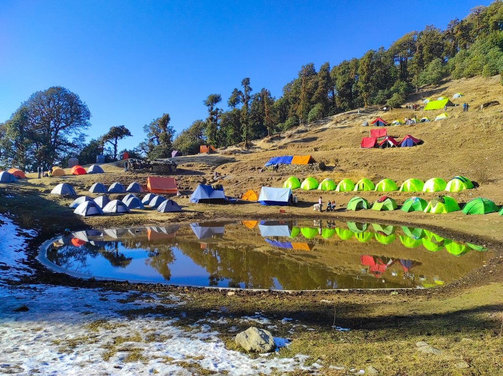
After you are ready to start walking. It is only a matter of 1.5 km before you finally arrive at Mulling campsite. The campsite is extremely pleasant and the long tiredness will just vanish away. Colourful flowers decorate the campsite as the turquoise river gushes by. You can have your hot tea gazing at the beautiful sunset alongside the river on green meadows. After having an early dinner, retire to your tents. It is important to get proper rest after dinner as it is your first night in a camp at a high altitude. Rest well and give your body time to adapt to the high-altitude condition so that you can wake up fresh for your trek the next day.
Day 3
Mulling to Kara
Today will be a little shorter day compared to yesterday but will be filled with bigger surprises. The start will be with a gradual ascent and rocky route. Today, you will have to cross some tricky sections, which are actually hidden boulders. Make your way through rocks for 1.5 km until you arrive at an amazing waterfall. Initially, you will also see a patch of the forested area where it gets darker and chillier and you have to cross the stream to get to the other side of the huge meadows forming a different yet picturesque landscape. Today you are going to face two major challenges one is crossing the gushing river by getting your feet in the icy cold water and the second is a steep ascent of 300 m which can be pretty tiring, especially with the weight on your back. The trail that takes you to the next campsite is clearly defined.
The ascent continues for another 1.7 km. You will be stunned as you arrive at this point because you will hear the sounds of the gushing river but see nothing. This is a natural phenomenon called the subterranean river, where the river flows underground. Take the most of this exceptional phenomenon. Now there will be a steep ascent for another 1.5 km.
There is a small stone bridge to cross a stream. After the steep ascent, you will be welcomed by another serene meadow. The grasslands have blossomed with vibrant flowers. Feel lucky to walk between these flowers for a kilometer, unless you reach your campsite. From the meadows, you will zig-zag across the mountain through a gradual uphill climb. The last bit of the hike involves you dipping your feet in the water once more to reach across to the warm respite of your campsite.
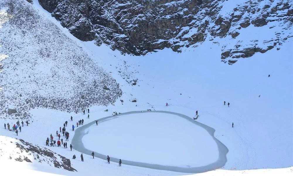
The campsite is somewhat similar to the last days. However, there is a lake that boasts a reflection of the surroundings. You can find many Shepherds with their cattle on Kara grassland. After reaching your campsite, have a delicious hot meal. On open meadows, beside the lake and grazing animals, sleep well in your tents.
Day 4
Rest and Acclimatization at Kara
Today is an important day in your trekking journey, a rest and acclimatization day. At high altitudes, oxygen levels drop, and your body needs time to adjust to this change. Acclimatization helps prevent altitude-related issues and ensures you stay fit and comfortable as you move higher. Giving your body this time to adapt is key to a safe and successful trek.
Kara is one of the most scenic campsites on the route. With a beautiful view of mighty peaks, the site also features the serene Kara Lake nearby, a magical spot where the mountains reflect perfectly in the calm, clear water. It’s a peaceful and picturesque place that feels like a dream.
Though it’s a rest day, it’s good to stay gently active. You can take short walks around the area, soak in the natural beauty, chat with fellow trekkers, or simply sit back and enjoy the views. Don’t forget to click some stunning pictures, this is one of the most scenic campsites of the entire trek.
Day 5
Kara to Phutsirang
This is the shortest day of the trek but the incline is much steeper compared to the day before. It is like a bonus day with a change in terrain and scenery. Today, we will also have multiple river crossings. Begin with the Bhabha river crossing followed by a steep ascent. Roll your pants up and step into the river, you will need to work as a team to get to the other side of the river. You will cross a collection of six streams to get to the other side. Fill the river with your eyes, as henceforth the river disappears flawlessly.
The Phutsirang Nala will be on the right as you walk on its left bank. The trail is a mix of boulders and stream crossing. Make sure you use your trekking poles efficiently and watch your step. You will require much more caution and balance on today’s trek. There are some sections, where the rocks are prone to slipping so you need to move continuously on these sections. For 4.5 km, there will be a steep ascent followed by a gradual path leading to open land.
There are two campsites, the lower and upper ones. But we climbed a little up for 200 meters towards the upper Phutsirang campsite. If there is too much snow, we will camp at the lower Pushtirang campsite, otherwise, we will climb up to the upper Phutsirang campsite. You will be delighted to take those last few steps up. The views from here are stupendous, more than you expected. You can see Hansbeshan Peak, Nimish Khango, Tari Khango, and Pin Bhaba Pass. Tuck in soon into your tents to get an adequate amount of rest and help your body recuperate after all the climbs.
Day 6
Phutsirang To Bwaldar via Bhaba Pass
Finally, wake up with a lot of enthusiasm and energy. The most awaited day of treading to the pass is a few hours away. You will begin early in the morning around 2 AM. Today you will have to conquer steep slopes to reach the pass connecting the Pin and Bhaba Valleys. During the journey you will notice a drastic change in the views from vegetation to the cold desert of Spiti.
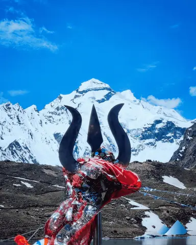
There will be a continuous steep ascent until the pass. Begin by walking on the loose scree. There will be a cold stream crossing followed by a steep climb. Walk up the steep hill until you reach the pass. You can see that the pass is the lowest point between the mountains. The pass is a confluence of Pin and Bhabha Valley, hence the name. From the top of the pass, you can see two distinct landscapes on two different sides. The geographical contradiction is the most in this part and as you keep crossing the pass, the landscape becomes rugged with the mountain turning brown and cold desserts beginning to show up.
If you look back towards the Bhabha side you can see the greenery from which you rose. And if you look at the Pin Valley side, you can find dry, beige mountains. You will soon enter the Spiti. The descent is steep and risky. Be careful and take your time to climb down. The descent is continuous for a long while until the slope gets gradual. Again there will be a river and stream crossing. You will arrive at the Bwaldar campsite after a long trek. Spend your night in the majestic sights, while you can also enjoy the amazing night view of abundance of stars.
Day 7
Bwaldar to Mudh and Drive to Kaza
The last day of the trek is here. It is the last chance to breathe in the astonishing mountains. Gather all the energy. We will start as early as possible. It is a gradual ascent with loose rocks and scree. Cross a river stream on a wooden bridge to enter on a flat path. From Bara Boulder, you will follow a gradual descent along a rock-filled, moraine section. The region here is dominated by red soil and small-sized red stones.
Enjoy the amazing trail henceforth which is laid with red soil. You will also cross Pharka village. There will be sheep flocks welcoming you. Walk for a while on this path to cross another bridge. Ahead of this bridge is the scenic Mudh village, a fantastic form of nature’s beauty.
The last section comes ahead. You will cross the Pin River over a suspension bridge. Then comes a small hike up to the Mudh village. It is the last village in Spiti in that region, about 50 km from Kaza. The village houses very few people and they surely are the friendliest and fittest lot. From Mudh, you will then get into your vehicle which will take you to Kaza. Kaza is the largest township in that region of Spiti and is also considered the commercial hub of Spiti Valley. You will find many shopping opportunities in Kaza as well as you can pay a visit to the monasteries. You will stay in Kaza for the night.
Day 8
Kaza To Manali
And the final day of the trek that takes you back to Manal. The journey will be long of 9-11 hours long. But the views will be astounding. You will cross the famous Rohtang Pass to reach Manali. TTH provides transportation for drop-off at Manali. You can expect to reach Manali by 7:00 pm, post which you can make your further bookings.
1. Insurance is mandatory.
2. Accommodation (as per the itinerary):
- Guesthouse in Kafnu on Day 1 (triple/quad sharing basis, males and females separate).
- Guesthouse in Kaza on Day 7 (triple/quad sharing basis, males and females separate).
- Camping during the trek from Day 2 to Day 6 (twin sharing basis).
3. Meals (Veg + Egg):
- Meals from Kafnu to Bwaldar.
- Day 1 dinner to Day 7 packed lunch.
4. Support:
- 1 versatile base camp manager: handles communication and deploys extra manpower in emergencies.
- 1 mountaineering and first aid qualified professional trek leader.
- 1 experienced high-altitude chef.
- Local experienced guides (number of guides depends on the group size).
- Adequate support staff.
5. Trek equipment:
- Sleeping bag, sleeping liners (if needed), mattresses, and utensils.
- 3-person all-season trekker tent (twin sharing), kitchen and dining tent, toilet tent.
- Camping stool, walkie-talkie.
- Ropes, helmet, ice axe, harness, gaiters, and crampons (if needed).
6. First aid:
- Medical kit, stretcher, oxygen cylinder, blood pressure monitor, oximeter, stethoscope.
7. Mules/porters to carry the main luggage.
8. All necessary permits and entry fees, up to the amount charged for Indians.
9. Services from Kafnu to Kaza.
10. Trek completion certificate.
- Insurance (For non-Indian Nationals, NRI or OCI card holders).
- Food during the transit.
- Any kind of personal expenses.
- Mule or porter to carry personal luggage.
- Emergency evacuation, hospitalization charge, etc.
- Any extra costs incurred due to extension/change of the itinerary due to natural calamities roadblocks, vehicle breakdown, etc. factors beyond our control
- Transportation (as per the itinerary):
- Shimla to Kafnu (day 1).
- Kaza to Manali (Day 8).
- Anything not specifically mentioned under the head Inclusion.
Things can be provided on demand and availability (participant has to pay extra for these things).
1- Satellite phone/set phone - a type of mobile phone that connects via radio links via satellites orbiting the Earth instead of terrestrial cell sites like cell phones. Therefore, they can operate in most geographic locations on the Earth's surface.
2- Gamow/PAC HAPO Bag (Portable Hyperbaric Bag) - is a unique, portable hyperbaric chamber for the treatment of acute mountain sickness (AMS), also known as altitude sickness.
3- AEDs (Automated External Defibrillators) - are portable life-saving devices designed to treat people experiencing sudden cardiac arrest, a medical condition in which the heart stops beating suddenly and unexpectedly.


No Details Found