- Overview
- Trip Outline
- Trip Includes
- Trip Excludes
- Gallery
- Booking
Name of Trek: Pin Parvati Pass Trek
Duration: 10 nights/11 days
Grade: Easy to Moderare
Maximum Alltitude: 5300 mtr/17,500 ft
Pickup and Drop Point: Manali
Region: Himachal Pradesh
Pin Parvati Pass takes you on a crazy ride through changing views—from the green Parvati Valley to Spiti's dry, colorful hills. One trek packs forests, flower fields, rocky trails, snow patches, and even cold desert vibes.
Kick off with a soak in Kheerganga's natural hot springs—perfect unwind before the hard stuff. You'll camp in quiet spots ringed by huge peaks, just you and total silence.
Hit the Parvati River's source—a calm, powerful moment deep in nature. Trails get tricky sometimes, but your guides keep things safe and fun, turning tough bits into highlights.
Topping out at 17,500 ft on the pass? Epic sights of two valleys and that sweet win feeling. Spot blue sheep, marmots, or ibex while hiking through wildflower zones.
It pushes your limits, but the raw beauty, peace, and rush make every step worth it.
Itineraries
Day 1
Your PlanManali to Barshaini and trek to Kalga
The adventurous journey of the trek will make a pleasurable trace when you reach Manali by 10 am in the morning and will leave for Barsheni Village which is surrounded by thick pine forest and green pastureland. Then further you will move to Kalga village which is a 1/2 hr trek from Barshaini. We will be taking a stop for lunch at Manikaran Gurudwara where you can visit the hot springs in the nearby premises. Hot langar is served at the gurudwara which you definitely need to try. After having our lunch we'll head towards Barshaini from where we have a little trekking to do towards Kalga. Please note that there is a network available at Kalga and your accommodation will be in a guest house.
Day 2
Kalga to Kheerganga
On the second day you will move to the long trail and continue from Kalga to move ahead and cross the bridge from here you can see River Parvati. Pin Parvati Pass Trek is a very enthralling experience to have fun while trekking and enjoy the enormous landscape view very closely. The trail goes through thick woodland cover and involves a sheer ascend of over 30 minutes.
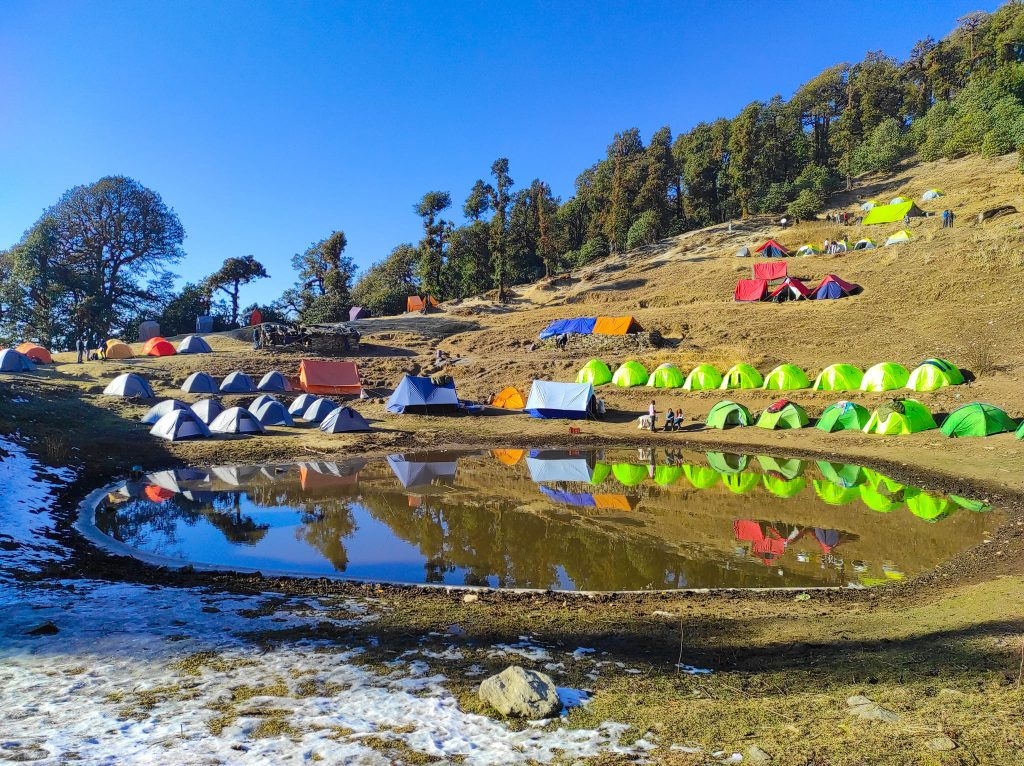
The climb goes on till you arrive at a point from where it takes a rational V turn and you can see the restroom at your left. From here it takes another 10 minutes of walk up to a tending pastureland where Khirganga is. The last elongated side engrosses a long climb through a pine woodland area and you will come across a beautiful waterfall. You will also come across a maggie point where you can stop for some refreshment. The entire trail is less of a steep ascent and more of a gradual ascent which is a mixture of Pine, Oak, Horse chestnut and Walnut trees. Kalga to Khirganga is a 10km trek that takes approximately 6-7 hours. After reaching Khirganga your accommodation will be in tents.
Day 3
Kheerganga to Tunda Bhuj
Today's trek will start for Tunda-Bhuj which is a steady climb out and from there you can view the Parvati River coming down from the mountain's left side. The track will move through long meadowland and the chirping of birds will give you gleaming happiness. The road from Khirganga is the first stream crossing starting with a constant ascent for about 20 minutes. Then you can see the temporary bridge over the edge of the mountains. There en route, you can see a small tent where the local wholesaler sells products. After 30 minutes you will walk out from the forest area and will see meadowland and the immense sight of the Dell. Now you will trail the high peak of the hill. Once you arrive at the top, the following will twirl within the hilly area and you see the huge area of the Parvati Valley in front. This will be the final overpass that you have to cross and you will reach Tunda-Bhuj situated at a high altitude of 11,000 ft above sea level. There you can see huge mountains covered with snow and the sight view looks very pretty.
Day 4
Tunda Bhuj to Thakur Kuan
As walking down you will reach pastureland through an opaque mixed jungle with a profusion of lovely flowers and Greenery Island. The landscape view of Tunda Bhuj is very easy but the distance is somewhat tough as the bridge is very long to cross and time consuming. Crossing the bridge to the further side of the stream takes time to follow up the peak. It takes 15 minutes to reach the steady climb as you pass through an inclined rocky meadow land. Trekking in Manali discover the prettiness of lovely landscape views and enhance the beautiful picturesque. As you start for the further trail you will go upto a high level and the landscape view can be seen as very striking. After the early rise crossways the Pandu Bridge, walk down towards the Parvati River at your right takes 15 minutes to pass through the fields .Many shepherds can be seen with their group on the way. By evening time, you will reach the Thakur Kuan which is situated at a high altitude of 11,650- ft high above sea level.
Day 5
Thakur Kuan to Odi Thach
The next morning you will feel great after taking good rest as you have to get prepared for the adventures which lie ahead. As this is the easiest day of your trek it won't take a huge toll on your body. You will cross the terrain region and then cross multiple streams coming your way. The day starts with a mild ascent followed by a slightly steep rise in the trail that will take you to the first river crossing. Further, you will find the Parvati River on the left part which looks very attractive. Then you will follow the big forest area and meadow land which can be seen aside from the Parvati River and enter the Thakur Kuan region which is surrounded by the pasture of orchard flowers and small trees. The Pandu bridge which is the most tricky patch comes after 1.5 hours of trek. It is recommended that all trekkers stay together in a group while crossing this natural bridge. This bridge is a natural formation created by huge boulders over the river. After crossing the adventurous Pandu Bridge, the trail is easy to walk as it is a flat ground that requires minimum effort. The trail spreads out in numerous directions as it is a shepherd trail. Remember to follow the group so that you do not get lost amid the labyrinth of trek routes. There are many water points before Pandu Bridge where you can refill your water bottles. After reaching Odi Thach we'll be camping there for the night which is one of the windiest campsites. Odi Thach is a beautiful meadow with the majestic Mt. Kullu Eiger peak overlooking the meadow.
Day 6
Odi Thach to Mantalai Lake
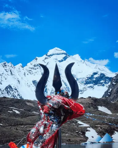
Today, we'll be covering a distance of 12k m which will take around 7-8 hours. This route is a bit muddy which at times can be slippery so it is important to be cautious. You will come across the moraine area which comes right after crossing the muddy surface. It has a steep ascent which requires a lot of physical energy to climb. So it is important to climb at your own pace. Mantalai Lake is the starting point of the Parvati River and you can also visit a small temple there. Your next campsite is just 45 minutes from here. The lake is at a higher altitude so there are chances of getting AMS. It is important to keep your body hydrated enough so that you are not hit by AMS.
Day 7
Mantalai Lake to Summit Camp
After leaving the striking place of Mantalai Lake you will cross the river lane which is a very hefty part of the trek and then you will walk through high rocky areas and glaciers. Then you will climb towards the right side of the slope, follow the trail which is very long and takes 9-10 hours. It takes around to climb the high mountain above at 14850 feet. Then you will walk to the campsite area, steep rocks will make you feel tired. Then you will reach to base camp which is surrounded by greenery everywhere and big glaciers. There you will stay in base camp and take rest for an hour and have a delicious dinner.
Day 8
Summit Camp to Pin Parvati Pass to Pin base/ Bedu Thatch
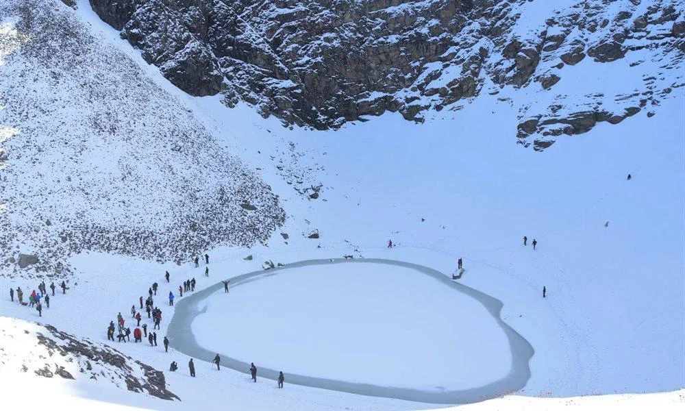
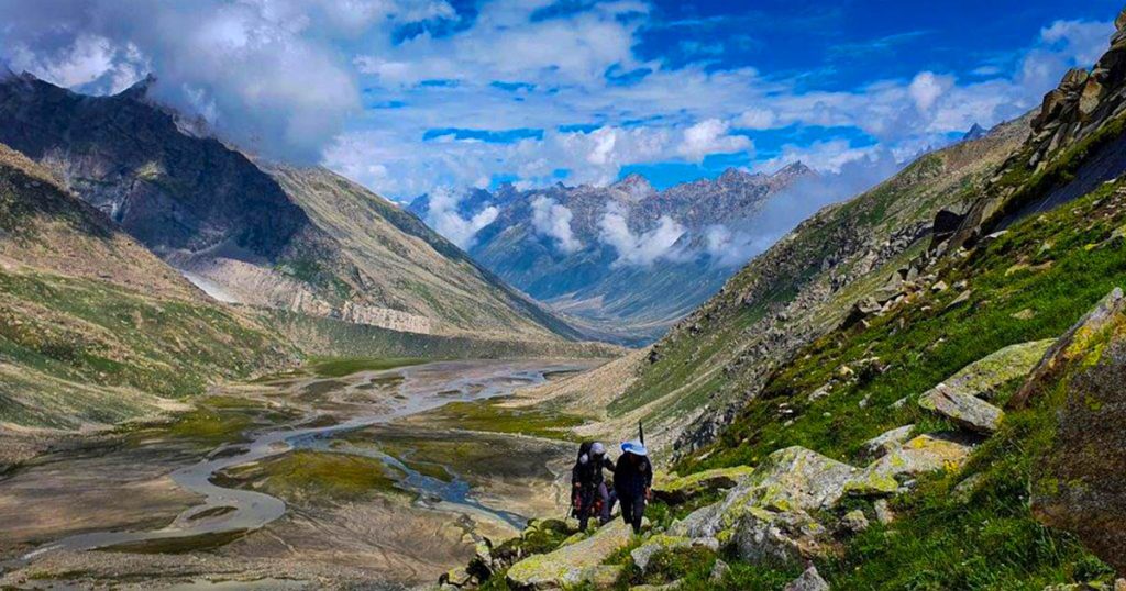
The trek begins another day after long hours of rest and after a long voyage you will then enter in Spiti Valley. The trail now climbs for an hour amid the glacier and a rock facade. After three hours of sturdy climbing you will arrive at the top of the pass at 17,500 feet from where you can look the way of Pin Valley towards Srikhand Mahadev. The follow come down over flurry and ice fields, covered with grasses and high rocks and stone will also come in your way. At this point, you will need to be very careful as there you will see very hefty paths which cross the dense forest lane and wild areas. The base camp is located in the centre of three vales. Moving further you can view the ranges of Dibibokri and Kulu Makalu which looks very fascinating and eye catchy as it is covered by large mountains and ice.
Day 9
Pin Base to Tiya
On this day will be trekking to Tiya which is approximately 12km. It is a gradual descent for most of the trek. It is a barren land which is surrounded by tall mountains. You will be able to see the trail of Bhaba Pass on this route. Your campsite at Tiya has a beautiful setting but it gets cold at night. It is important to have proper layering while you sleep in your tents.
Day 10
Tiya to Mud Drive to Kaza
Today we'll be trekking to Mud which is the last village of Pin Valley. It is a flat walk on the road almost on the road. After reaching Mud we will be driving to Kaza. Necessary arrangements will be made for your pick up after which we'll be driving to Kaza. Your accommodation will be in a guesthouse at Kaza.
Day 11
Kaza to Manali
The way back to Manali will be by the familiar road, the drive starting at 6 You’ll reach Manali between 5:00 pm and 6:00 pm. You can book your travel any time after 7:30 pm.
1. Accommodation (as per the itinerary):
- Guest house, Home Stay.
- Camping while the trek (Twin sharing basis).
2. Meals (Veg + Egg):
- Meals while on trek(Veg + Egg).
- Day 1 dinner to Day 10 pack lunch.
3. Support:
- 1 Versatile base camp manager: handles communication and deploys extra manpower in emergencies.
- 1 Mountaineering & First aid qualified professional trek Leader.
- 1 Experienced high-altitude chef.
- Local experienced guides (Number of guides depending on the group size).
- Enough support staff.
4. Trek equipment:
- Sleeping bag, Sleeping liners (if required), mattresses, and Utensils.
- 3 men all season trekker tent (twin sharing), Kitchen & Dining tent, Toilet tent.
- Camping stool, Walkie talkie.
- Ropes, Helmet, Ice axe, Harness, Gaiters & crampons (if required).
5. First aid:
- Medical kit, Stretcher, Oxygen cylinder, Blood pressure monitor, Oximeter, Stethoscope.
6. Transportation (as per the itinerary):
- Transport till road head and return. (Manali to Barsheni and Mud to Kaza and Kaza to Manali, as per itinerary).
7. Mules/porters to carry the central luggage.
8. Cloakroom facility available at the base camp for additional luggage.
9. All necessary permits and entry fees, up to the amount charged for Indians.
10. Trek Completion Certificate.
- Insurance (Mandatory).
- Food during the transit.
- Any kind of personal expenses.
- Mule or porter to carry personal luggage.
- Emergency evacuation, hospitalization charge, etc.
- Any extra costs incurred due to extension/change of the itinerary due to natural calamities roadblocks, vehicle breakdown, etc. factors beyond our control
- Anything not specifically mentioned under the head Inclusion.
Things can be provided on demand and availability (participant has to pay extra for these things).
1- Satellite phone/set phone - is a type of mobile phone that connects via radio links via satellites orbiting the Earth instead of terrestrial cell sites like cellphones. Therefore, they can operate in most geographic locations on the Earth's surface.
2- Gamow/PAC HAPO Bag (Portable Hyperbaric Bag) - is a unique, portable hyperbaric chamber for the treatment of acute mountain sickness (AMS), also known as altitude sickness.
3- AEDs (Automated External Defibrillators) - are portable life-saving devices designed to treat people experiencing sudden cardiac arrest, a medical condition in which the heart stops beating suddenly and unexpectedly.